My starting point is always the same (and it doesn't involve batteries!)-
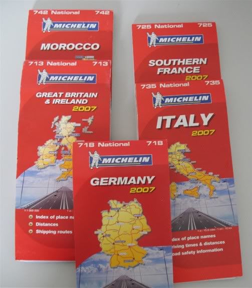
The type of map is important. Many of the true 'touring bikers' that I've come across use the Michelin type pictured, but Philips also do a fine range that others find easier on the eye because their colouring is different. Have a look at both in WH Smiffs before you buy. There is a specific reason for the use of these maps , which is that 'roads of outstanding beauty' are clearly highlighted by a green line (I've arrowed examples below).
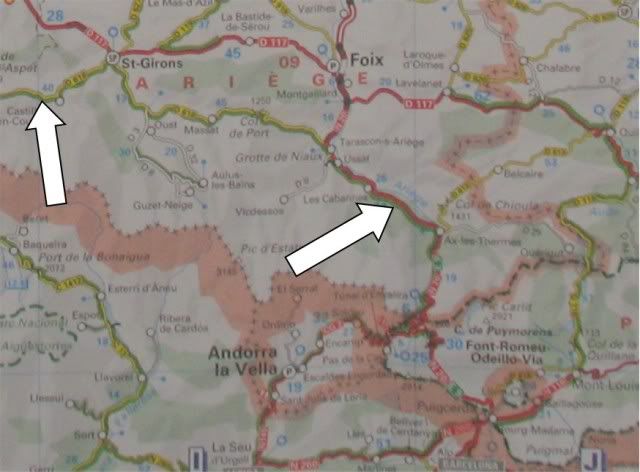
Basically, before you set off you know that someone has already been there, seen it and thought it special. I've mapped the Pyrenees, Andorra, Southern France and Morocco, as well Hartside, Wordsworth's run etc etc exactly the same way and it works. The only other thing I would say, is that I would trust Michelin insofar as, the roads they call beautiful are just that.
Find a starting point which is reasonably close to the start of the nice roads AND is easy to find. Examples are
the Skipton Little Chef at the junction of 5 main roads or perhaps Bayston Services, where the northern contingent meet up with the locals to get lost in Wales

Next is the endpoint. Sounds daft, but make sure you have one. Usually this will be th starting point but certainly not always. Touring abroad will mean that each days riding usually ends up at a different place altogether.
Then there's the issue of what's in between. By way of an example would be the Wordsworth run. The plan was an easy one: I wanted as many passes and lakes as possible (which had to include Hardknott and Kirkstone) linked together by nice roads, so it went summat like this;
Job 1- Google "Passes in Cumbria" the Cumbria Tourist Board site was wonderfully helpful, not only naming a bunch of Passes that I'd ridden in parts before, but also giving me road designations and even the photo's included in the post itself.
Job 2- Take the road designations and plot all of them onto the same map. The questions are simple; Are the Passes near together? Can they be easily linked by nice roads? Do any need to be dropped out because they're 'Out on a spurr' somewhere? Does the milage involved look feasible, based on a steady riding Blackbird jockey, with pillion? Try to use as few junctions and turns as possible, people don't get lost on straight roads (errrm usually
 .
.Job 3- Open MapSource (or TomTom's equivalent) and set up the start point as a waypoint, then click into route mode and get up close and personal when it comes to mapping
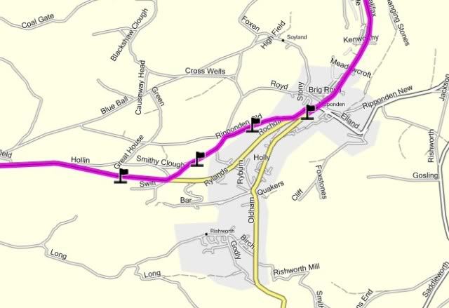
To digress for a moment- My two biggest failings with mapping a route were impatience and not checking the end result. The result of that, was as follows. The first piccie is a map showing a route from my old place through Ripponden and out over the tops to Hebden Bridge. Mapped at 2 miles (reasonable) it's an ideal kick off----Until that is I ended up being directed up a God-forsaken farm track
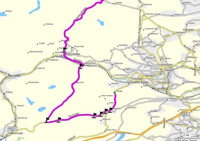
(the second photo) which can only be seen when working from say .5 of a mile. I had to fake the above photo's because I've just upgraded to v11 mapping which is far better but, this quirk in the routing occured every time on the old mapping without fail.
This issue was never a problem when close to home (I knew the roads after all) but half way through a run in a place I'd never been----------Errrm I'd utter those immortal words "Wish I'd brough the GS" or more fashionably "Naaah it's fine ya fookin puffs, greenlaning and bog-hoppin's what the
 was built for" etc etc
 The next common fook up I always made, came from the same problem. The route below is a perfectly straightforward dual carriageway run from Keighley to Skipton- no probs
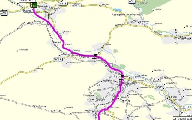
---- until zoomed in:

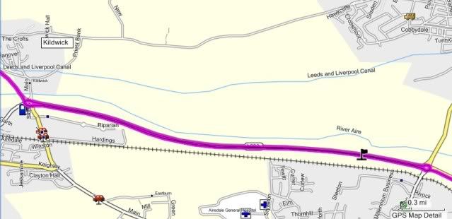
Then I find that whilst mapping from too far out (2 miles this time), I've placed a point marker on the opposing carriageway. Garmin has done as it's told taken me to the first available roundabout, u-turned me and taken me back. Not only that, but the next point flag is up at Skipton where I need to be, so Garmin has taken me back to the next nearest roundabout, u-turned me again and set me off back up the same road towards Skipton. Again- not a major problem on a short dual carriageway, but on the M1 or some autobahn somewhere-------------
So then--- back to the point. Working with the map under the left hand and the mouse under the right, carefully create the route in MapSource. The waypoints don't need to be too close together at all, but when you drop a waypoint in, just back-check it quickly to ensure the ol' purple line is on the road you want it on and doesn't drift off to errrr 'save you time'
Job 4- When the route is complete, figure for fuel and stops. On a ride out, I usually account for the first fill up at 70 miles, so locate an appropriate fuel stop at the distance you prefer or the first one available BELOW that distance. Then refuel at 120 mile (140 max) thereafter. As for lunch stops if you don't know any; Google it, ask on the site and work them in. Personally, I prefer fuel to be within say 10 miles of food. That way folks eat, fuel up and can then settle in to a nice focussed, switched on, undisturbed 20 or 30 miles riding before fag stops and leg stretching stuff.
Job 5- You have a route (rather than a map and a faint idea of where you're going). The next thing is following it on the sat nav and leading other riders around it. It's not for me to advise on group riding etiquette, coz I don't tend to use second rider drop offs and other methods of keeping it together. In actual fact, what I do do helps me as well the people behind me. I slow down for each junction (stop if necessary) and stack 'em up. Firstly, no-one gets lost. Secondly, I have time to look at the sat nav screen, listen to the sat nav voice and tie the two together to hit the right turn even in a busy town centre. Don't be rushed at turns. Take yer time, read the road and the sat nav and you've done all you can
Importantly--- Understand this!! Your sat nav (and I don't give fook who made it) is going to send you off route every once in a while
 . It's unavoidable, it will be annoying but it will happen!! Two things- pull in and just look at the screen. Zoom out or in if you need to, but then do what you need to do to get back on route. Don't be tempted to wing-it and ride miles off course and then (if you're lucky) get back on course and try telling everyone it was planned. If you do that,the day will come (and often frequently) when you're leading a large group of very tired riders around the arse end of nowhere on roads which are unsuitable. So the (purely personal) rule is; If it (or I) fook up- cough to it early and make it right
  .
.Another thing worth bearing in mind is that some of the bikes behind you may well be running the same route as you are, so they may well know how to get it back to right. No probs, just coz your Garmin's thrown a shoe, let yer mates put you back on track and away you go.
Hope it helps and my thanks to Linda, my secretary, for typing this dictation as a Word Doc to be copied and pasted here today
Bless 'em all eh